
A word of warning from the start. You simply can’t write a short report about this race, so if you’re not in the form for a saga, turn away now.
The Art O’ Neill has a great history to it but this will be long enough without going into that now, so you can read up on it here.
This is a race I’ve wanted to do for years but with a limit of 200 entrants each year it can be hard to get an entry. So despite a year in which I’ve ran less miles than in the previous five & was no way fit enough for it, I still couldn’t stop myself from entering this year’s lottery. (Between a massively increased workload & a non-running related back injury I simply haven’t been putting in the miles this past year)
So mid-November rolls around & Success! I’ve been drawn from the hat. I’d be lying if I said the nerves didn’t kick in. Am I mad? It’s a 33 mile race over some of the toughest terrain in the country & I don’t even know if my back will hold out. People were telling me I was daft & to put it off to another year (& in my mind I could see my physio probably roll her eyes when she heard about it). So I made a deal with myself. Compete in ‘Run the Line’ in late November, an 18mile run over the Dublin Mountains, and see how I get on. If my back held up I’d plough on with the AON, if it gave problems I’d pull out. I wasn’t worried about fitness - that could be worked on. So I arrived up to Dublin at the tail end of Storm Dessie or Ciara & endured nearly three & half hours of hell over the mountains in gale force winds & driving, freezing rain. But I loved every bit of it & never felt a single twinge in my back, so the decision was made. AON was a go go.
Fast forward six weeks & I’m again arriving in Dublin, woefully underprepared for an even longer trek over the mountains. But instead of storms to deal with, we now have the coldest night of the winter so far. It’s -5 outside & the word is that the mountains are covered in snow. I can’t help but be a little excited about this. My aim was just to finish & I’d been telling people I expected to finish in less than 10 hours but I had confided in a small few that it could be anything from 8 – 10 hours (Which was usually met with a look of complete scepticism).
The race is made up of three parts. Leg 1 is 30k, starts in Dublin Castle and is 99% road (mostly uphill) running with a small bit of cross country & finishes in Ballinagee, in the foothills of the Wicklow Mountains. Leg 2 brings you cross country over the first mountain pass to Oakwood & Leg 3 brings you cross country again over Table Track & down to Barravore in the Glenmalure Valley. Whilst Leg 1 is a straight forward road race, Legs 2 & 3 are point to point with a map & compass with a multitude of routes.
As the race follows in the pattern of Art’s escape, we start out at 1am (Walkers at midnight). We line up in the courtyard in Dublin Castle with a few minutes to go & its bloody freezing but the gun goes and we’re off through the streets of Dublin. It’s a bit surreal to be doing this in the middle of the night & God knows what the weekend revellers are thinking as they step out of the pubs to be nearly bowled over by a group of runners lit up like Christmas trees.
I’ve decided to go out at a nice easy training pace as there’s a long way to go & I need to save the legs, so I set off around 8.45min/mile pace. The bunch splits into three distinct groups as the speedies disappear into the distance ahead & another slower group behind. There’s about 30 in my group & I fall in with a gang of lads who turn out to be from France. We pass through Harolds Cross, past Terenure & Tempelogue & take a right hand turn to head out towards Firhouse. This is where the race starts as from here on out it’s nearly all uphill. I know from driving the route that these roads have long winding bends with gentle climbing & I start crossing over going point to point on the curves. One other lad comes with me & I’m sure everybody else is wondering what the hell we are at as we seem to be crossing over and back for no reason, but sure enough, without upping the pace we distance the French group. We pass through Rathfarnam & this is the end of the suburbs as we enter the darkness of the countryside.
We have a small drop before we hit the big stuff. I’d kept the pace steady but knew this was all about to stop. We had averaged about 50ft of climbing a mile up to now but then, as we hit gradients of over 15%, we start covering upwards of 400ft of climbing per mile. And it’s relentless, think of Ryehill, only 6 times longer. We had already picked up the tail end of the walkers who started an hour earlier but it’s hard to tell the runners from the walkers as everyone falls into a quick march.
We reach Stone Cross after 9 miles & have already covered 1000ft of climbing. This is the first of the minor roads & from the first step its like Bambi on Ice. The Yak Trax come out & they are great. Even on sheet ice you can run as normal. There’s more climbing as we cover another 600ft of elevation before we drop down past the Kilbride Army camp & cross the border into Wicklow. I’d kept up a steady run / quick march since the start of the tough climbs & had passed a good few people whilst only being passed by a small few others in the process. The downhill was a good respite & I pushed on to pass a few more before coming to the first off road section.
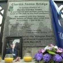
This was a steep downhill field which was nice & springy until we hit the frozen tractor trails. They were lethal & ankle breakers if you weren’t careful. It was only a short introduction though & a mile later we hit the roads again & crossed over the Liffey at Ballysmuttan Bridge. (Now named after Ciaran Jones, this bridge was the scene of tragedy in 2011 as an off duty Garda was swept away in floodwaters whilst helping people affected by the floods. The bridge always has a bit of a surreal feel to it as it’s decorated in wreaths & ribbons in his memory)
It had been a nice drop from 1600ft down to 740ft but as we cross the river we start climbing again until we reach Checkpoint 1 in Ballynultagh Woods at mile 18. It’s like a party in the woods with hot drinks, food, DJ, & fires going. It was also completely covered in snow so that it resembled an alpine ski village.
As soon as you stop you start getting cold so I grabbed my drop bag & jump in beside the fires. I strip off my sweaty upper layers & put on fresh thermal base layers & an extra jacket. We’re about to head up into the mountains proper, it’s going to be cold & we’ll be moving much slower. Proper gear is essential here! I ditch the road runners & put on my trusty Salomon’s & I also get out the most important gear from here on out, my map & compass. I grab a roll, some soup, fill my Camelback with water & I’m gone. Surprisingly I stayed over 20mins here, it certainly didn’t feel that long but it’d be easy to get comfy by the fire & not want to leave. Looking at the results there were 5 DNF’s at CP1. It was now 04:45am. I’d been awake for 22 hours, had covered 18 miles & knew that I hadn’t run longer than 18 miles since training for Dublin 2014. And whilst the race was more than half complete, the hard part was just beginning.
I left CP1 to a short little downhill section before we hit the bottom of Mullaghcleevaun Mountain. From here on it’s like a game of chess. We have a start & end point & how you make your way between them is up to you. Everyone plays a different move to try & gain an advantage on their competitors.
Now I had no grand notions of a getting good placing in this race but once the gun goes I can’t help but fall into race mode & my mind just works that way. Whilst you may not be anywhere near the pointy end of things you are still racing those around you. After forming the initial groupings leaving Dublin Castle I had gently moved through the field & from Stone Cross I had steadily passed people. So as I reached the true start of the cross country I looked around & could see two groups ahead of me. One group had taken the short climb to my right up Black Hill and had a 5min gap on me & one had taken the longer climb up Mullaghcleevaun and had a 10min gap on me. Each route had their advantages & disadvantages. Black Hill had a short initial climb from where you could cut across the ridge through Billy Byrnes gap & down the Glenbride Valley. Whilst there were some defined tracks here you still have to climb up from the bottom of the valley to look for the entry point to the forest at the far end of Glenbride. The climb up Mullaghcleevaun had a long initial climb but once you were up high enough you could take a bearing & head for the forest entry & it would be mostly downhill. For me though there was still too much climbing. I had decided to cut them in half & take a direct line to the forest entry. It meant I was passing Billy Byrnes gap higher up but once over that I could keep a direct south bearing on a steady downhill. It just made for easy navigation & it was also the shortest route. The only issue was the underfoot conditions could be tough as I fight through the heather with no defined route.
It turned out though that I needn’t have worried about the heather as once we left the forest I looked up & all I could see was a sea of white reflecting off my torchlight. Everywhere had a thick covering of snow. I started my climb & realised early on that it was going to be a struggle. With every step you sank about a foot into the snow & every so often you hit a crag & could disappear up to your waist. I realised that this is the area that Maeve Noone remembers fondly from our previous recce ‘…one second he was there, the next he was gone…’ after I had disappeared into a hidden crag. The problem now was you couldn’t see anything under the snow. Whilst you could take a direct bearing because it was now a fairly smooth surface, you just never knew what was under you and every so often the snow would collapse as you hit a void.
The climb became torturous. Whilst it was no Everest we were still high & I was gasping for air (And God knows what the temperature was but it was well into the minus figures). My heart was racing & I had to stop every 10 – 15 steps to catch my breath. It became a slog to reach the pass & looking at the stats it took me 40mins to cover a mile up to the top of the pass. Once there I was at a height of 2,000ft (after dropping down to 1,250ft after CP1). When I looked around I could see a trail of head torches all over the mountain as everyone decided on their own route. I had tried to keep an eye on the two original groups as I climbed & the Black Hill group were over the gap & starting down the valley whilst the other group had just passed out of sight. One other runner had passed me in the meantime as he took a diagonal route up to higher ground.
Once over the pass my next landmark for a bearing point was the convergence of three small streams as they form a river. I wanted to hit just south of where they met which would keep me right on track for the forest entry. Although it was night time & you couldn’t see too far, you could be here during the daytime & it could be covered in fog & low cloud anyway so you need to be used to reading a map & looking for little landmarks or even listening for the stream. The problem was with so much snow I wasn’t sure if the streams would be flowing much. I keep an eye on the compass & keep heading south. It was all downhill now & was a great respite after the last climb although the pace was still relatively low due to the snow & ground conditions. Then I hear the flow of water. I stop to take a listen & realise it’s coming from underneath me. I’d hit a minor stream & it was covered over in snow & ice. I tentatively step across and instantly hear the rushing flow of the main river. Perfect, I’d hit the point just below where they meet. It’s a great confidence boost as it’s easy to start doubting your navigation. I find a safe crossing point & I’m off for the forest entry. I can see the Black Hill group below me in the valley & they seem to be following the course of the river down to the valley floor.
We’re getting lower again & the deep snow has abated but the ground is now marshy & criss-crossed with many streams as they run off Mullaghcleevaun so the pace is about 15min/mile. Ahead of me I spot what looks like a flag on a small pole & in the darkness it looks a bit like grave marker & is a bit eerie. I make my way to it & it’s a fluorescent flag on a stick. In the distance I can just about make out another one & they seem to be heading in the direct I want to go. It looks like someone has marked the route into the forest entry with flags every 100m or so & I’ve hit it bang on again. I can pick up the pace a bit as I don’t need to watch the compass now; I can just seek out the next flag & head for it. The path of the flags also have good crossing points on the various streams too so I made some good time here. I reckon these go on for about two miles & eventually I see the shadow of the forest loom ahead of me. As I spot the entry gate I realise there’s two lads just ahead of me. It must have been the group who went higher on Mullaghcleevaun earlier. They must have come down ahead of me but I didn’t see them as they never looked back so I never saw their torches. They seemed surprised to see me too & after a little conversation between them they took off at a run. Below me I could see the Black Hill group making their way up the tree line looking for the gate. I reckon I’ve put about 10mins into each group.
I enter the forest track & it’s great to be on solid ground again. The two lads ahead have a couple of hundred metres on me & are just rounding a bend ahead. I take off in pursuit but I realise I don’t have a lot of energy. I don’t fancy taking another gel yet & know I’m close to CP2 & some real food so decide to hold off. I run the downhill & flat sections but even the smallest incline has me slowing to a march. I round a bend & the two lads are much closer than I expected. They seem to be jogging until they get out of sight & then slowing. It gives me a boost & I take off after them. We hit the edge of the wood on the road to the Wicklow Gap & it’s the first sight of civilisation we’ve seen in 3 hours. We cross over the road into Oakwood & I catch up with the two lads, dibbing into CP2 just ahead of them.
I’d intended just a quick stop here for a cup of milky tea & a quick bite but the smell of the porridge quickly changed my mind. I grabbed a bowl a sat by the fire with the two lads who were from Cork. A short while later the Black Hill group arrived in & just after them my French buddies from earlier that must have made good time over the mountains. It was time to go. It’s now 7:30am. I’ve been awake for nearly 25 hours, racing for 6 ½ hours & I’ve covered 25 miles with approximately 8 miles to go.
I dibbed out with two northerners who arrived in grabbed a cup of tea & took it with them. So leaving CP2 the race was on with the French, the Northerners & the Cork lads. I tried to take off at a run but soon realised I had stiffened up too much and had to walk it off for a few minutes. Just as the hills start again I feel pleasantly unencumbered until I realise I’ve left my map back at CP2. Aarrgh. Decisions, decisions. I know the route well but also know that the route from Art’s Cross to Table Track is a complete maze. You don’t want to be caught out in conditions like this. I’m half a mile from CP2 & as I make my way back I pass the French & Cork groups plus a couple more new faces heading off on their last leg. All my hard work undone. I find my maps in one of the tents & take off again. I’ve warmed up a bit by now so I soon have them in my sights again although I’ve just added an extra mile to an already long event.
From CP2 there are again various choices of routes. You can take the route west along the Kings River to where the Glenreebrook River branches off. This will bring you through the forest & gently up to the foot of the climb to Arts Cross. It’s easy in terms of navigation as you just follow the river but I knew from a recent recce that there had been tree felling in the area & it can be tricky underfoot where that has happened. My original plan had me taking a route east where the forest road took a medium gradient to Forest Track & from there it’s a straight run down to Glenreebrook River. As I looked ahead of me the French, Cork lads & two new lads were taking a route straight up the hillside which cut back in half way along Forest track. That made my mind up for me & I take off after them. This is very steep & involves some real climbing as you need to pull yourself up the hillside with your hands. But we reach Forest Track all as one group & also just as the Northerners pass (They had taken the forest road). All level pegging again.
We all take off at a canter & I soon realise that my burst to catch everyone has me bushed. I stop to grab a caffeine gel & take a look around. It’s getting bright now & there’s no need for my head torch but across the far side of the valley, 5 miles away, I can see the line of torches still making their way over Billy Byrnes Gap. I say a silent ‘Thank God’ that that’s over for me but as I turn towards my destination the climb to Art’s Cross looms ominously in the distance.
Forest Track drops gently down to the Glenreebrook River & I’m able to keep within shouting distance of those up ahead. Everyone else heads for the river whilst I take a left beforehand & take a fence line that heads in the same direction and meets the river further up. The river winds & winds whilst the fence runs straight so it’s much shorter. I quickly overtake the two new faces whilst I realise the French & Cork lads have crossed the river & are heading on a different route altogether. I also notice a fourth group arriving up from Kings Rivers & reckon it must be the Black Hill group. They also seem to be heading for the other route. I’m not familiar with this route but I reckon it’ll bring them out near Three Lakes. This means they’re more than likely not going to Art’s Cross & my battle with them is over.
(Art’s Cross is where Art O’ Neill died & there is a cross erected in his memory. It’s located on the highest part of the course & requires a deviation from the optimal route. The cross isn’t a Checkpoint that you have to hit whilst taking part but visiting the cross is in the spirit of the event. I’d decided beforehand that as it’s my first time I’d head for the cross. I learned afterwards that a lot of Ultras bypass it whist the guided walkers usually head for it)
I head for the bottom of the waterfall which climbs to Art’s Cross. The race brief recommends keeping to the left of the river to avoid the marshiest ground but by crossing over early I can take a more direct route. I recce’d this area a couple of weeks ago & the ground was good so I cross early & head direct for the waterfall. I’ve opened up a good 5 minute gap on the two new lads & when I hit the waterfall I’ve gained about 100ft of elevation on them. I look back & they seem to have teamed up. They have stopped by the river near where I crossed & appear to debating crossing over or heading around the long way as per the race brief. They eventually decide to cross early too & take off after me.
Ahead of me is the steep climb up to Art’s Cross. I was here a few weeks ago & managed a quick & steady climb. Today was not going to be similar. We’re up at around 1,450ft elevation & the snow coverage is getting thicker with every step. I look up & can’t see a clear path. I climb a little on the western side of the waterfall but it’s tough going & I cross the river to the eastern side to where I’ve previously climbed. It’s bloody hard & dangerous, there’s deep snow & any exposed rock is just covered in ice. It’s a steep climb & the best footing is often beside the edge but one slip there & you could fall 20ft into the river. I end up just grabbing whatever exposed heather there is & pulling myself up the climb. It’s really tough going & by the time I reach the top of the waterfall I am beat. It’s a climb of about 410ft from the bottom of the waterfall up, over a distance of about a quarter of a mile and it took me 20mins.
It’s a beautiful clear day & it’s bright out now. Looking around it’s just a sea of white & looks fantastic but I know I have a slog of about 250meters over to the cross from here & the snow is deep. I’ve come this far so there’s no turning back now.
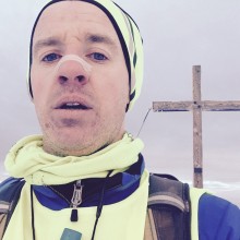
I know where I need to go but getting there is the problem. I’m at around 2,000ft elevation & it’s deep snow. The top layer is a frozen crust and with every step you think it’s going to hold until, as you raise your back foot and all your weight goes on, you break through & sink in up to your knees. Snow shoes, not trail shoes are what’s needed. It’s even tougher than the first mountain pass & every so often you sink up to your chest & have to use the heather to haul yourself out. I spot the cross about 50m away & head for it only to sink deep again. My left hamstring goes into spasm & I’m in agony. I try to stretch it but it’s encased in snow & I struggle to move it. I eventually get out & stretch it whilst I lie in the snow. This trek to the cross has been hell. I finally get there & take a few minutes to get some salt tablets & food in. This is the highest point of the course at about 2,100ft & you can see for miles. I take a few quick photos & I remember the shout from the steward as I left CP2, ‘Don’t forget the selfie with the cross…..’. I’m not normally one for selfies but here goes…..
About a quarter mile way I can see the top of the waterfall. The two new lads have obviously had enough of the snow & bypassed the cross whilst the two northerners have just reached the top of the Waterfall. As it’s such a clear day & there’s no background noise their conversation carries across the mountain. ‘Are we heading up the cross? Hell no, are you mad?’ Everyone has clearly had enough of the snow! Interestingly I can see new groups about a half mile beyond the waterfall who must have taken the other route but they were also heading straight for Table Track.
In my head all my battles are done. I was thoroughly pissed off & exhausted after the climb up to the cross whilst everyone else seemed to avoid it. (The single set of footprints in the snow were a giveaway) All my CP2 competitors have bypassed the cross & headed straight for Table Track & with about 4 miles to go over this snowy terrain my sub-10 was looking seriously unlikely. Time to break out the chocolate! I had one bar of chocolate in case I needed a boost & now was as good a time as any. The thing was frozen bloody solid! It just wasn’t my day. Lesson learned, don’t go to the cross.
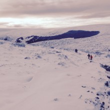
Normally from here your biggest obstacle is maze of peat hags in your way. You know you need to keep a south west bearing to hit south of Three Lakes but there is no direct route to take as you head through a maze of large peat hags, some of which are twice your height. Even though you want to go one direction you have to thread your way through the maze whilst watching the compass to make sure you’re not actually doubling back on yourself. It’s also usually covered in low cloud so even if you climbed on top of a hag to take a bearing off something, you’d have about 30 – 40ft visibility. Today you could see for miles & it was just an undulating white mass. This was good in one way as I could ditch the compass but I also knew that it was going to be a long slog through the snow.
Away in the distance I can just make out the edge of the forest that leads down to Table Track. I take off and soon fall in behind a group who have just come over the other route from CP2. They are making good headway & creating a path through the snow so the pace is surprisingly better than expected. Instead of a maze through the hags we are now walking over them & where the taller ones are we end up sliding down them like kids. On some of the larger hags we see icicles about 3ft long. In my head I’m thinking my daughter would love this & can’t help humming the tune ‘Let it go, let it go’. The group ahead of me are like Nordic cross country skiers & distance me again as we reach Table Track but as I finally leave the deep snow behind & hit the last leg home on forest road I catch one of the new lads from CP2.
From here the majority of people will take Table Track to the south of the River Avonbeg that winds a bit but from looking at the maps there was a more direct route north of the river which added in an extra bit of mountainside descending. Last throw of the dice! On paper it looked good but soon after I made the call I knew I’d made the wrong decision. I was climbing gently but the route down to the river was steep & rough. The trail of blood and guts across the snow from some recently disembowelled animal didn’t make me feel any better. About 100ft below me in the valley I could see the Nordic skiers & the new guy had well distanced me. The climb down the hillside wasn’t easy with some recent tree felling having occurred & I had to be careful not to twist an ankle.
Finally I reach the river and it feels like the home stretch at last. The track starts to climb again & as I round a bend I come across the French group. They reckon there’s about 3k left. My watch start beeping & as I look at it I see 9:**:** before the battery dies. I have no idea how close to 10 hours I was but I decide to go for it regardless. The track becomes a mass of jagged rocks & sheet ice & near impossible to run on. This goes on for about a quarter mile before the trees thin out & the icy parts ease off. I up the pace as much as I can & put big distance between me & the French but now my only target is the sub-10. The ground is terrible & I have to pick every step carefully even though I’m nearly flat out. Every step is jarring & sends stabbing pains up through my femurs & into my back. After 30+ miles my back has finally given up & is spasm.
The rocks give way to a nice forest path at last & I keep the pace up. It feels like I should nearly be there. I pass a walker who is heading in the opposite direction & ask her how long left. ‘2k’ she roars, ‘Keep Going’. 2k, WTF? I keep it going. My lungs are on fire & my back is in agony & with each step I’m roaring like a mad man with pain. I start passing more walkers now & keep asking them how long left. They roar words of encouragement but no one seems to understand what I’m asking. God knows how I sound.
It’s daft. I’m finishing this like it’s a 5k & for what? It seems to go on forever. I know the finish line is on a river crossing which is at river level & I’m still about 30ft above it. I see smoke ahead & reckon that must be the finish. I’m gaining on the Nordic skiers again & as I round a bend to where the smoke is coming from it turns out to be campers & the gang ahead are already rounding another bend.
I’m done, I’m beat. I stop & drop my hands to my knees gasping for air. I look around & see the tents around the next bend. I put on one last burst & there is the river. 33.5miles & 4,700ft of climbing later, home at last with 9:37:08 on the clock. I’m delighted but too damn sore to care anymore. I’m just happy it’s over. I've now been awake for 28 hours.
Chatting to people at the finish line, lads who have run it previously reckon the snow made the course nearly an hour slower so with that in mind & some course knowledge in my pocket I have a sub-8 to target next year.
Kenneth O'Hara.