You’ve never been truly lost until you’ve been dropped in the middle of a mountain range with a map, compass & a list of numbers as your only directions home. BUT, if this sounds like fun to you then Rogaine is the sport you want. Basically long distance orienteering, the name of the game is to score as many points as possible by hitting grid reference control points within a specified time cut off. The person with the most points at the end wins.
So this year I entered the Rogaine 2017 - 6 hour event which was being held (somewhere) in the Wicklow Mountain National Park. We were told to buy the East West Map for Lugnaquilla & Glendalough, so we knew the course would be somewhere within that area and a couple of weeks before race day the tone for the race was set when the race start & base camp location was issued as a set of grid reference co-ordinates: O077001 (Wicklow Gap).
Whilst I’ve some limited experience on mountains & have entered races before with some level of map & compass work required, this level of navigation (with no GPS back up allowed) was a new departure for me & I was really looking forward to it. I was confident in my map reading skills but I didn’t really have anything concrete to back up my confidence yet, so I had no idea how the event was going to go. The aim for the day was to finish within the 6hr cut off with points on the board. For every minute you finish over the 6 hours you are docked 100 points so a 10 min delay could wipe out your whole score (and it happens).
So I rock up to base camp for kit check early on Sunday morning & the weather couldn’t be worse for this type of event. Low cloud, mist & fog. Whilst I don’t mind running in any weather, for navigation it’s not great as you can’t sight any landmarks. I was going to need my wits about me! There was about 60 of us in the 6 hour event across 35 teams (I was a team of 1) whilst the 24hour event was already 18 hours in (a whole different type of madness), so we were all due to finish at 2pm.
8.00am rolled around & the race starts with everyone being handed an envelope with a list of 19no grid reference coordinates. It’s up to ourselves to plot the coordinates on our map & plot a route ourselves. This is the most important part of the whole event, get this wrong & you’re not going to hit any controls. I plot them out & thankfully double check everything as I had two marked wrong (This surprisingly took a half hour but it seemed to be the case for most people). Due to the weather conditions I want to omit as much open mountain as possible. In that situation you are totally dependent on your map & compass and with cloud down around your knees there’s nothing to sight off & it’s easy to go wrong.
Looking over the control locations I immediately decide to omit some of the most east & west outliers. One of the westernmost controls is located at Three Lakes near Conavalla Mountain (734m). I know this area from the Art O Neill race & it is a maze of 10 foot tall peat hags which are near impossible to negotiate in low cloud. I reckon I could lose plenty of time up there. The easternmost control is located in Laragh, five miles distant. Whilst the distance didn’t faze me & I could pick up other controls along the way, the constant five mile climb from Laragh to the Wicklow Gap didn’t appeal to me. With all controls worth an equal 100 points there was no benefit to hitting these far flung controls. (In the 24hr event the harder controls can be worth up to 400 points)
I decide to take a clockwise loop around base camp picking up the closer controls. The route would allow me use a lot of natural features such as streams & forests as guides, would omit a lot of open mountain & I’d never be too far away from base camp if I needed to chase time.
Control 1 at Turlough Hill (681m) (Irelands only pumped water storage power station) was probably the easiest on the course & most people went for it. It allowed us use the ESB service road to the top of the mountain & get some early points on the board. After this though it was using the map proper. I’m well able to read a map & know the difference on a map between a path / track / trail / road / service road etc. What I wasn’t used to was how each of these items were represented in real life (What’s a track / trail etc on the ground?). After the first control I easily lost about 15 minutes where I started to doubt myself & I had a bit of back and forth on various trails. I eventually settled into it & got a feel for the ‘on the ground’ conditions and headed for my second control.
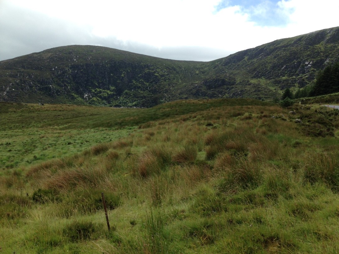
There’s something eerie about standing on a what’s effectively a cliff edge looking down into a sea of cloud & thinking, I don’t know what’s down there but that’s where I have to go. The sign beside me stating ‘Beware edge & rock falls’ didn’t beef up my confidence much. But I knew if I went over, the natural contours would draw me down to the stream below which I could follow to the control, so off I went. Luckily enough I soon broke through the cloud line & I could pick up the stream easily enough. I followed it down to the valley floor and bar a detour around a large marsh on the low point of the valley floor I was able to follow this to the control area. It’s an amazing place, surrounded on three sides by mountains with a forested valley in front. The only sign of life I see are the herds of wild deer who are watching me from the distance. I continue along the stream & pick up the next control easily on the forest edge. It’s a confidence boost as it allows me to have faith in my navigation skills. 200 points on the board.
The next control is across the Wicklow Gap road. I know I can follow the stream out to it so continue on. The terrain is constantly changing from marsh, to forest, to boulder fields & each one has its own tests. At one point I give up on the land & decide to just use the stream (which has now grown to a small river). It’s just below knee height & is grand for wading through but it’s definitely easier than the felled forest either side. I come to a thick forest & there is no definitive track. There are a few small trails, the type you often see when you’re out walking in the woods & think to yourself ‘I wonder where they go’ but never bother to find out. Well I had no choice but to find out. It’s amazing how dark it can get under the tree canopy & I feel like a small child exploring the woods but it’s allowing me to follow the stream so I'm happy to explore. I eventually come to a bridge at a Coillte service road which I know I can follow to the main road. I also know there’s ancient walking route called St Kevin’s Way around here which would save me some time. I spot it and am delighted to see they’ve just built new boardwalks along it. Some people don’t like using these but after the past few miles I’ve had, they feel like heaven. I follow the trail to Annalecka Bridge, cross over the road into the forest beyond and pick up the next control easily enough at a forest trail end. 300 points on the board.
To get to the next point I can go back down the hill to the main road & take a new entrance into the woods, but this means dropping down from 450m elevation to 350m & I would then have to climb back up to 600m. I want to try & eliminate the climbing if possible to save the legs & energy so I decide against that route. My location is right at the edge of the map & it looks like the track I’m on might intersect with the track I want to be on but it’s off the edge of the map & I’m not sure. I decide to try it & head off but after a few hundred meters the track turns in the opposite direction I wanted so I bailed on it (Looking at the online map later I should have trusted my instincts as it looped around to meet it). I still don’t want to go all the way back to the road so I decide to cut through the forest (never an easy decision). It drops off into a small valley so I can see what’s ahead of me. The first half is old felled forest whilst the far side of the stream is newly planted forest (3 – 4 years old). I manage the first part ok (even though it’s about chest high grass) as I picked up a few deer trails & cross the stream easily enough. The new forest on the opposite side consists of approximately 8ft high pines trees & I spot a fire break (a line of about a 6ft gap between trees) which runs vertically uphill, generally in the direction I want to go. For some reason this just dead ends half way up & there is no clear way through. I have no choice but to make my own way through (Not as easy as it seems). Very soon I resemble Wile E Coyote after he’s run into a cactus, I have pine needles sticking into me everywhere. I can’t see in front of me, I can’t see behind me, the ground cover is atrocious & I end up upside down with my head in the ditch at least twice. I have no choice but to use the compass to make sure I’m heading east but you just have to go where the trees will let you at times. I come to a tall ridge in front of me & haul myself up & nearly cry with joy when I see I’m on the track. I’m on a large turnabout too for Coillte trucks so I can pinpoint exactly the spot on the map & it’s perfect. I follow it downhill to a stream from where I have a long but easy to follow trail uphill to the next control. 400 on the board.
From here I know it’s going to be tougher. I’m on the edge of the forest with Tonaglee Mountain (817m) in front of me. I’m now heading out into open mountain & will be compass dependent for the next while. I have two choices. I can climb up to the pass between Tonaglee & Lough Outer or I can contour around Tonaglee on the same level & bypass the mountain. The mountain pass means another 250m of climbing from where I am and through intermittent breaks in the cloud I can see quite a way up along some very tough terrain & don’t spot the top. It’s an easy decision, I’m going round. It adds on a nice bit of distance but it should be quicker. As I head off from the control I meet a team of lads coming the other way, one just looks at me & says ‘Jaysus, this is some slog’, I’m glad I’m not the only one feeling it.
Contouring around a mountain can be a pain. Your ankles can take a beating due to the constant strain from the angle plus your natural instinct when you come to an obstacle is to go around it on the downside so if you’re not careful you can start losing elevation very easily. So every so often I’d try to climb a bit when I saw a nice easy, clear section. During one of these I look up and about 30ft in front of me is a large stag. I reckon he’s about 8ft tall & due to the cloud all I can make out is his black outline. It’s creepy looking but he has no interest in me & saunters off into the mist. (Once they hear you coming you’re fine, it’s when you startle them you can have trouble). The terrain on this section is tough. There are a lot of large boulder fields where you really have to mind your footing or you could snap a leg easily in a hole. After what seems like an age I feel like I should be coming around the outer edge of the mountain but my compass still reads as heading south, I think I should be heading east but that would bring me straight up the mountain. I keep going south along the same level & slowly but surely I start to turn (at least the compass tells me I’m turning anyway, I can’t really tell with the cloud). As if by magic the clouds part & I have a view for miles below me. I realise the leeside of the mountain was sheltered from the wind and was covered in mist & cloud whilst the windward side was clear & I could now see where I was going for the first time in the day (after 4 hours). I look down below me & was disappointed that about a mile distant, but directly in line with me, is the base camp. I thought I was way further along on the mountain but that’s the perils of open mountain navigation, it’s very hard to gauge the ground you are covering. It at least gives me my location though & I can pick up the speed (well a little bit anyway) as I know now where I need to go.
I come round the far side of Tonaglee & have a good view beyond. I can see the general location of two more controls & reckon I’ll get to these before I have to turn back (One about a half mile distance, the next about 1.5 miles). The first is on a rock outcrop of one of Tonaglee’s lower steps. It’s at about 580m elevation so is slightly below me & looks like an easy route over. The terrain is deceptive though & I stupidly end up dropping down about 100m to a stream crossing before having to climb back up. This loses me time & on top of that my legs are telling me they’ve now had enough. I’m starting to get spasms in a lot of places & don’t think I’ll hold out much longer. I get to the ridge & after a loop of the area pick up the control. 500 on the board.
Big decision time. I have just over 1 ½ hours left & I can see in the distance the next control location at Aska Lake. Do I have the legs to get me there & back in time as there is also a control just south of here which I’m going to pick up anyway on the way back. With my legs being the deciding factor I cut my losses & ignore Aska Lake and I head directly south for what will be by last control. The downhill is painful, with each step I’m getting spasms. I’ve long since run out of water but I have a feeling the leg cramps are more to do with fitness rather than dehydration.
After a long painful descent I eventually hit the Wicklow Gap road which I have to cross. It’s the first bit of solid ground I’ve come across in 2 ½ hours & it feels great. I take a few minutes to stretch out the legs before crossing over into the marsh on the opposite side where there’s a control somewhere just a few hundred meters off the road on fairly open, marshy ground. The note with the grid reference states ‘Boulder’ so with much better visibility I reckon it should be easy to spot but after looping around a bit I hit a service road & I’ve found I had gone too far southeast. I backtrack towards base camp and I see another runner heading the opposite direction, he lets a roar that ‘it’s near the tailings pile’ and sure enough in the distance I see a tailings heap with a large boulder beside it. I get there & they’ve done a good job of hiding the control in the middle of three boulders. 600 on the board.
After an argument with some briars I make it back to the main road where I have 5.05 on the clock. I’ve covered 15 miles already & there’s just over one uphill mile to base camp. I know if I head back now I’ll be very early but I don’t think I can manage to hit another control & get back under the cut off time so off I go. I have the luxury of knowing I’m well within the cut off & can take it easy as I don’t think I could run much at this stage.
Job done & target hit of points on the board and under the cut off at 5.19. A lot of time left but not enough to do anything with. I had no illusions that 600 points would be competitive but I was happy. Looking at the results I was comfortably mid table in joint 17th position, not bad for a first timer. The winner, amazingly, hit 15 controls & still finished with 17mins to spare. On that terrain that is a phenomenal performance. Looking at the results, nine teams missed the cut off with two teams scoring -6800 as they were 1 ¼ hours late (Someone obviously got lost).
Looking back I think I missed out on two easy controls. The first through bad decisions after control 1 where I should have followed a trail up to Tomaneena Mountain before going over the cliff edge but I was still getting to grips with the maps at that stage & didn’t realise it was so close. The next was Aska Lake towards the end. With 40 minutes left on the clock it was possibly doable. But who knows?
A great event in a fantastic location & hosted by all volunteers. A big shout of thanks to Paul Mahon (Who has to be a bit sadistic to set up that course) & his crew.